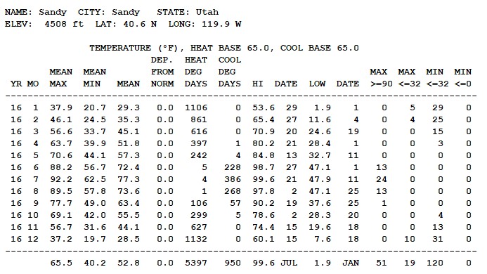
Calendar Year 2016 Climatological Summary
Temperature
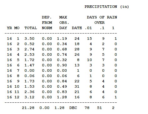
Precipitation
Wind

Temperatures ranged from 99.6.7F on July 21 to 1.9F on January 1. Precipitation was above average at 21/.28" with January having the highest mount with 3.50". As usual there is not much to say about the wind, as maximum was just 44 mph and the predominate direction was from the south southhwest.
December 2016 Climatological Summary
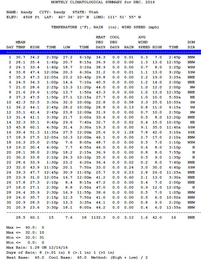
For the second year in a row a major winter storm hit the Salt Lake valley (and much of Utah) on Christmas Day, providing yet another "White Christmas". The Christmas day storm produced 11" of snow.
December continued the normal winter weather pattern that began in earnest in early November, at month's end the local mountains were well ahead of normal snow pack. Should the winter continue to produced above normal snows pack in the mountains, there will be sufficient water next summer. The air was cold this December with four days recording low temperatures below 10 degrees Fahrenheit. Those days were the 18,19,26 and 27th. Every day during the month saw temperatures below freezing (32 F), while the temperature never rose above freezing on 10 of the 31 days in December. This was clearly much colder than recent Decembers.
Water content of the storm on December 16th produced an exceptional 1.28" of moisture. Winds before that storm hit were quite strong with a gust to 42 mph. While that's a high speed for this area, compared to other locations in the valley, that was rather wimpy.
November 2016 Climatological Summary
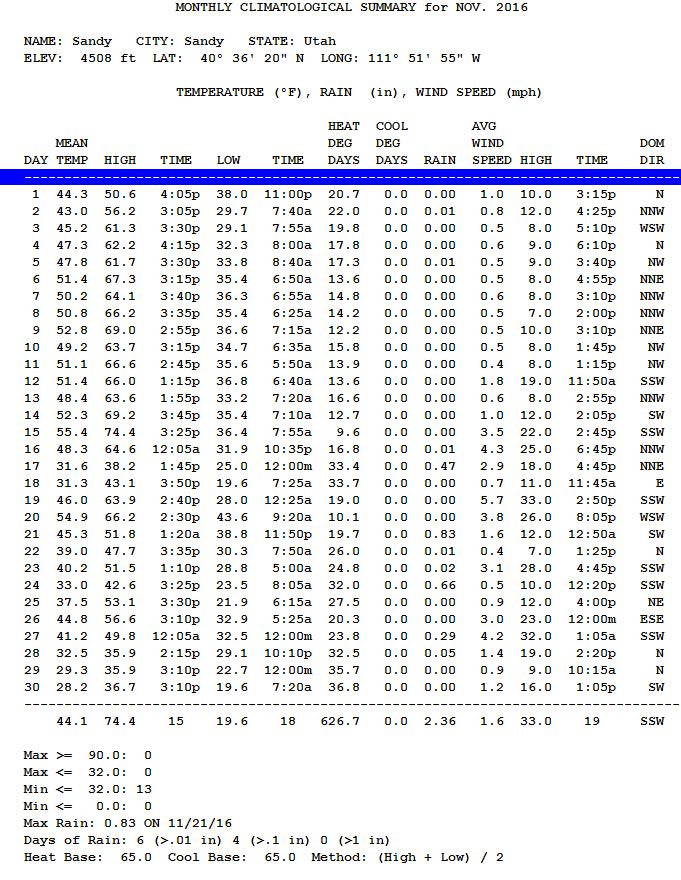
The mild fall enjoyed through October, abruptly came to an end on November 17th when winter like weather arrived. The high temperature on November 15th was 74 degrees, while the high temperature on November 17th was just 38 degrees. That day the first snow of the season arrived (see below). This snow produced 0.47 inches and was followed on the 21st by 0.83 inches and 0.66 inches on the 24th. This string of storms clearly broke the dry had mild pattern that had persisted up to that time and put the Salt Lake City area into winter weather. Every day during the month saw temperatures rise above freezing (32 F / 0 C); yet half the days in November recorded temperatures below freezing. Appropriately the coldest temperature in November was 19 degrees recorded on the last day of the month, November 30th.
A quick moving cold front dropped about 2" of snow overnight. About 12 inches (30 cm) in the nearby mountains. The national weather service in Salt Lake City, located about 300' below the elevation of my home, recorded its first freezing temperature of the season with this storm. Meanwhile at my home a below freezing temperature has been reached 8 times this season including this morning. The wet snow produced almost 1/2 inch of precipitation (1.3 cm)
October 2016 Climatological Summary
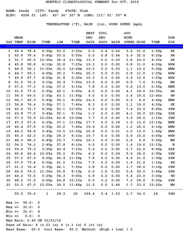
The Weather in October 2016 was simply boring. Boring is not good. So far since January 1, 2016, this site has recorded less than 15 inches ( 38.1 cm) of precipitation. Twenty inches (50.8 cm) is normal for this area. The late summer, early fall Utah monsoon never materialized in a meaningful way. The bottom line, without at least normal snow fall in the mountains this winter, water will be rationed next summer. Precipitation in northern Utah is critically lacking.
Storms in October came early and late in the month. 0.80" ( 2.03 cm) fell October 1-3 and 0.49" ( 1.24 cm) fell October 31st. The first frost came early on October 6. There were 4 mornings with temperatures below freezing 32 F (0 C).
September 2016 Climatological Summary

September 2016 in the Salt Lake City area was pretty much normal. The August-September monsoon season left lots of rain in central and southern Utah, while in the north it was rather "hit and miss". At SandyWeather.com (Weather Underground SANDYUT25), the rainfall was about average at 1.73" (4.4 cm), which made for a nice start on replenishing ground moisture after the long hot summer of 2016. Most of the rain came during September 22-24 - 1.54" ( 3.9 cm). There was only one day (September 19) when the temperature exceeded 90 degrees F (32.2 C). That's a rather small number for a normal September. That stormy period brought in enough cold air, that on the morning of September 25, the low was just 37.6 degrees F (3.1 C). While I have seen 5" of snow fall in September (1971), snow and freezing temperatures are unusual during September. The average date of the first frost (0 C) is around October 13.
August 2016 Climatological Summary
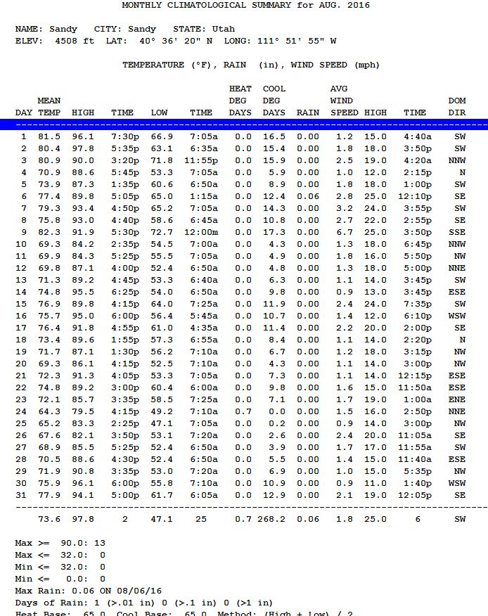
The summer of 2016 was quite dry in the Salt Lake City area. While some spots in the valley had more rainfall that my Sandy North station, it was still a very dry and rather hot summer. Total precipitation at my station for the summer months June, July and August was 0.96" (2.4 cm); most of which (0.90" or 2.3 cm) came in the month of June. August had a paltry 0.06" (0.15 cm). The summer mean temperature in 2015 was 73.8 F (2.3.2 C), while the mean temperature for 2016 was 74.4 F (23.6 C). Hopefully the late summer,early fall monsoon will kick in during September. In August is was limited to southern Utah. Rain is much needed this fall to replenish ground moisture in the mountains, otherwise, much of the snow melt next spring will simply flow into the ground, rather than into the streams to fill our reservoirs. Without that, we will need much above average mountain snowfall to have plenty of water next summer.
July 2016 Climatological Summary
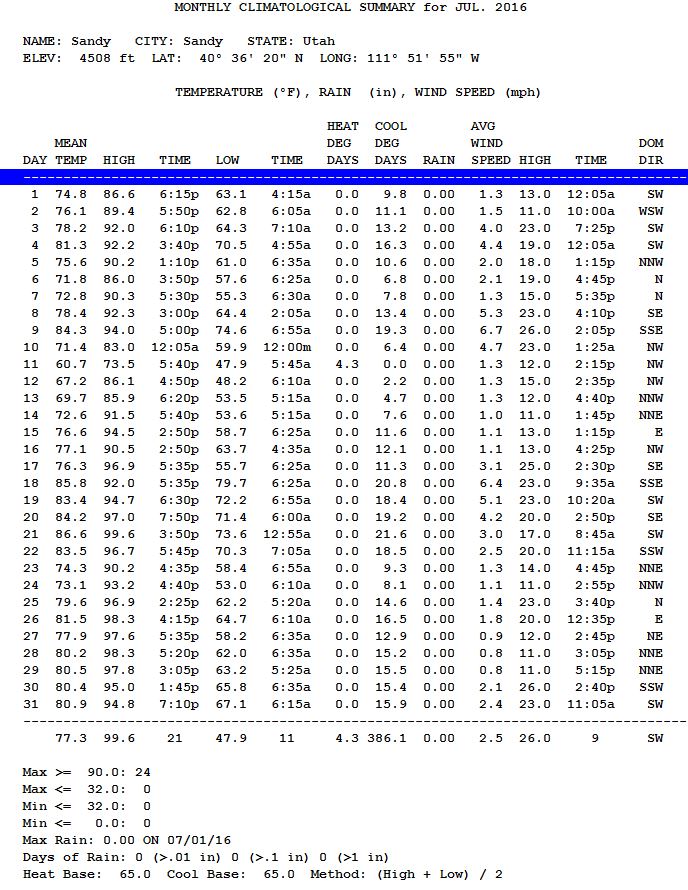
This July was simply "HOT and DRY"! At this Sandy station there was only a trace of precipitation. Yes, enough rain fell out of the sky to cover our sidewalk completely on July 30th. That said, this July has 13 days of temperatures greater than 90 F (32.2 C), June 2016 has a like amount of days. I used to think my weather station recorded a few degrees lower than it should on very hot summer days. This year, I used Weather Underground and looked at other stations in my area. They had similar temperatures to mine. I also noted that the airport (official SLC Weather office) was generally 3 degrees warmer. Tonight on the 6pm news Mr. Eubank suggested that the thermometer at the airport might be broken. I laughed at that, since there is little chance that is the issue. Nevertheless, the airport certainly appears to be the hottest place in the Salt Lake valley. Clearly, being close to the Great Salt Lake, it has one of the lowest elevations in the valley. If things stay normal, the summer monsoon will start soon, temperatures will go down, and precipitation will go up.
June 2016 Climatological Summary
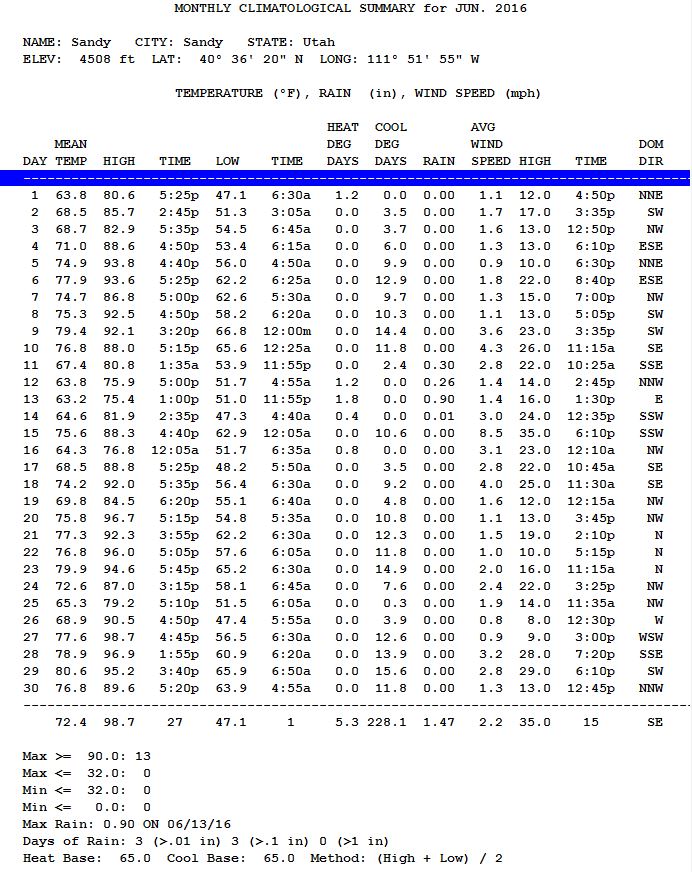
June 2016 was quite normal. Typically the first week in June is stormy; but not this June. The story week in 2016 was the 2nd week when 0.93" of rain feel June 6-9. Just like last year the final days of June were very hot! Last year it was unusual in that it was the hottest part of the whole summer. At this Sandy location June 27th is still among the hottest day this summer with a high of 98.7 F (37.1 C).
June 2016 Climatological Summary
June 2016 was quite normal. Typically the first week in June is stormy; but not this June. The story week in 2016 was the 2nd week when 0.93" of rain feel June 6-9. Just like last year the final days of June were very hot! Last year it was unusual in that it was the hottest part of the whole summer. At this Sandy location June 27th is still the hottest day this summer with a high of 98.7.
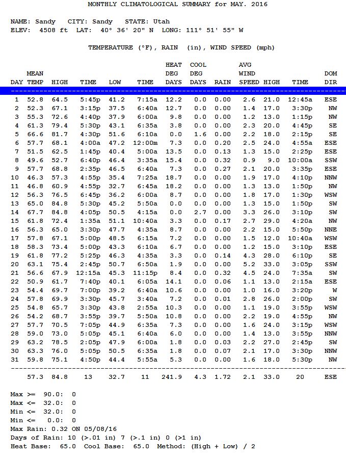
May 2016 Climatological Summary
Salt Lake's normal spring weather pattern continued into May. A year ago heavy rains came, in much the same way they come in late July and August, as moisture streamed northward off the Pacific coast of Southern California and Mexico. We saw a small amount of that this May, but mostly the rain came from normal late spring frontal activity. The total was 1.72" (4.37 cm), far short of May 2015's total of 5.12" (13.28cm). It was last May's rainfall that prevent water use restrictions from taking place. For the Summer of 2016, we should be water restriction free as the past winter and spring have been much more normal in the Salt Lake City area. The frequent rainfall kept May temperatures below normal, but when Summer hits in early June, we should expect much hotter temperatures. Again in this sheltered part of the valley winds are seldom strong. Max wind speed was 33 mph (4.37 cm). There were no days with temperatures below freezing (32 F / 0 C). May 13 is the average date of the last frost in the Salt Lake City area.
April 2016 Climatological Summary
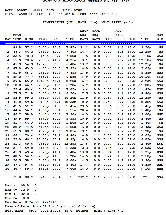
A near normal March and April back-to-back? Thanks to the return of El Nino, weather in these parts seems rather "normal" again. April 2015 had rather normal precipitation as well, but December 2014 - March 2015 was crazy warn with little precipitation. 2.53" of rain is a good value for April. The last week of the month was exceptionally wet with over 1.5 inches (3.8 cm) of rain. All lawns in the are were looking exceptionally green after all that rain. Spring is on average the wettest time of year in the Salt Lake City area. April 2015 and April 2016 had about the same mean temperature as well at 51-52 F (10.5 C). There were but three days with temperatures below freezing, and freezing temperatures generally continue unto early May.
March 2016 Climatological Summary
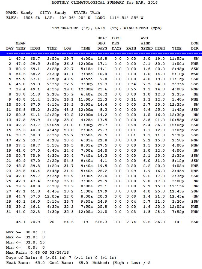
Thankfully winter like weather returned in March and the skies provided a goodly amount of precipitation, nearly 2.74" of water fell during march helping us to get back on track for precipitation. If April is similarly normal we should be OK for our water needs this coming summer. Two back to back early week storms (March 22 and 28) produced most of the precipitation during March. The storm on the 22nd produced 3.5 inches (9 cm) of snow; while the 28th produced 2 inches of snow (5cm).
Like normal half of the morning low temperatures in march were below freezing 32 F (0 C).
February 2016 Climatological Summary
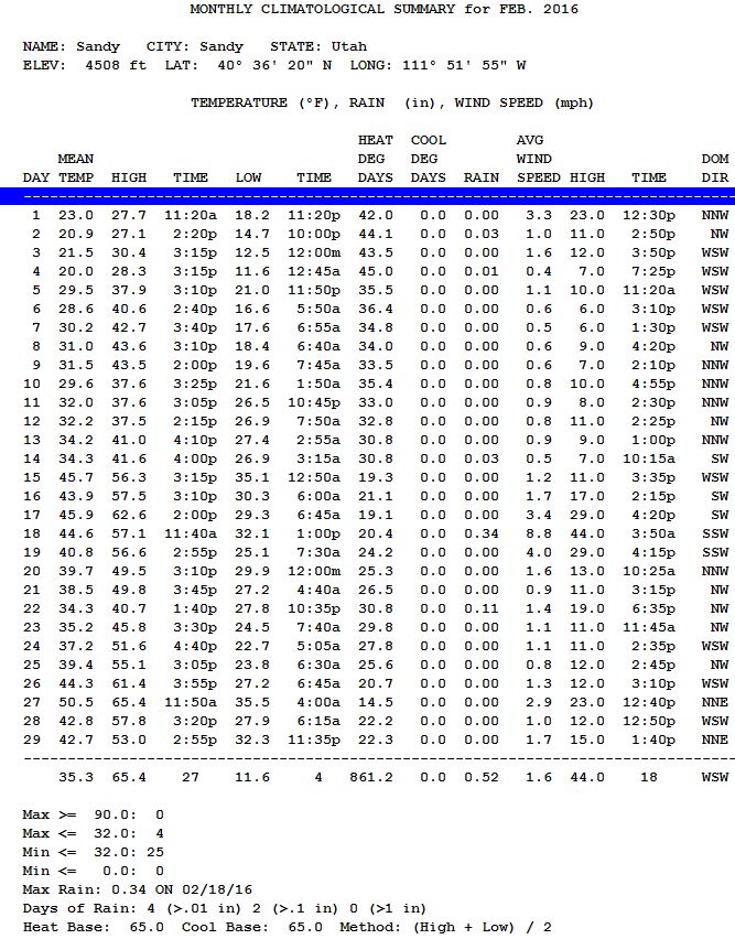
As soon as January ended so did a near normal winter season. February had average temperatures, but little precipitation, which totaled only 0.52". The mean temperature last February was a warm 41.7 degrees Fahrenheit (5.4 degrees Celsius). This year was a much more normal 35.3 F ( 1.8 C). On 25 of 29 days, the low temperature was below freezing (32 F - 0 C). That's quite normal for the month of February. Compare that with just 18 days a year ago. Most of the precipitation came on February 18th (0.34" - 0.86 cm). A cold front passed early that morning with very high winds. This station recorded a high wind speed of 44 mph (71 km/h). That nearly equaled the highest ever recorded here (48 mph). Meanwhile, at the same time, other parts of the valley were hit with near hurricane force winds up to 70 mph (112 km/h). March and April will need to provide above average precipitation to supply our water needs for the coming summer months.
January 2016 Climatological Summary
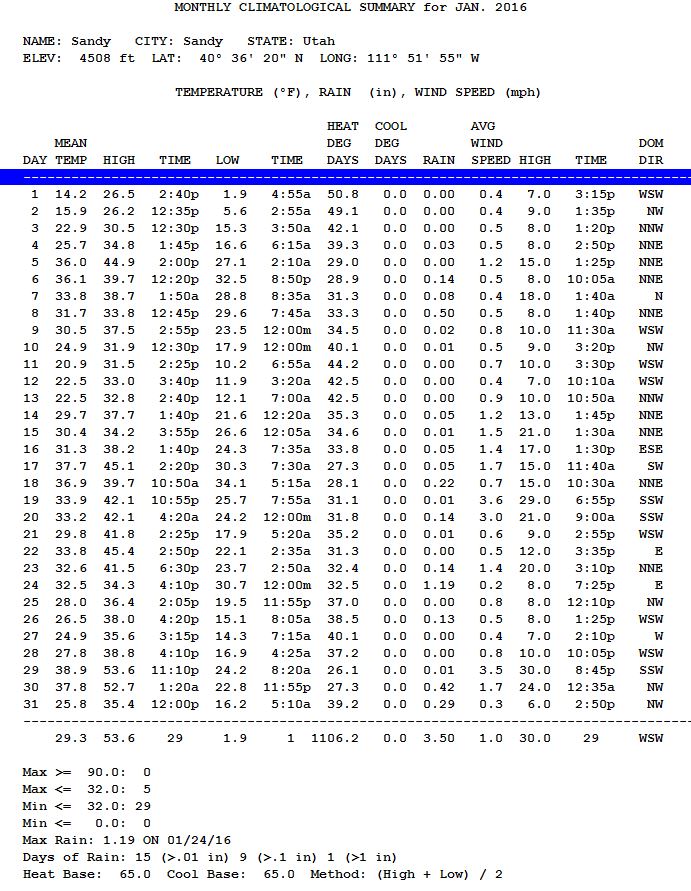
Ever since Christmas Day - December 25, 2015, we've experienced real WINTER WEATHER, such as we've not had in 2-3 years. This is great for building the snow pack in our mountains that will become next year's water supply. The snow just kept on coming and the grass (in shady areas) has been continually covered with snow since then. In the shade, in the back yard, the snow depth today is over 12" and that show contains lots of water. The water equivalent for the snow that fell in January 2016 was 3.50 inches, that's well above the average for a normal January. The coldest day of the winter season occurred on the morning of January 1, when the temperature dropped to 2 degrees Fahrenheit (-17 Cellists).
It's not often that a well defined WARM front can be felt in Utah, but on Saturday afternoon, just after 2pm a warm front passed. It has just started to snow, when the warm air arrived and turned the snow to rain.
After night fall, the cold front then hit at about 8:45pm and the rain turned back to snow. Ar first the snow was heavy and wet. Then the intensity of the storm dropped off, but light snow continued ALL night and through noon on Sunday January 24. The snow never seemed to pile up more than 3-4", but the water content of the snow was incredible, 1.30" of water content came from the rain and now combined. Usually, under normal conditions it would take 12" of snow to produce that much water content. As temperatures remained between 30.8 and 32.2 degrees during the storm, the snow that did fall continued to melt into the snow below it; that is what produced some of the heaviest (and wettest) snow I can remember.