April 2026 Climatological Summary
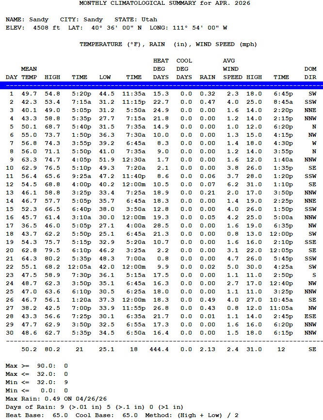
Thank heaven for the rain we received in April. The total was 2.13" (5.4 cm), close to the 29-year average of 2.37" ( 6.2 cm). This total was helpful even if it did not exceed the 29-year average. The total for the year todate is just 4.86" (12.3 cm). Typically we rely on the winter snow and spring rainfall to provide needed water for summer and into the fall.
THe mean temperature was 50.2 F (10.1 °C) which was cooler than March's average of 52.4 F (12.3 °C). It is weird to see such a reversal between months. The warmest day was April 21st with 80.2 F (26.8 °C). Meanwhile, there were nine days when the temperature fell below 32 F, (0.0 °C).
March 2026 Climatological Summary
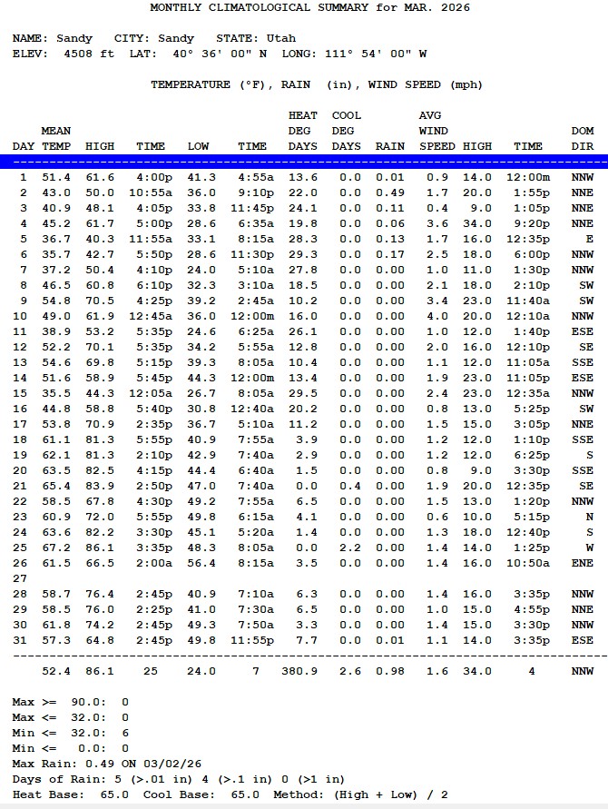
March 2026 was a lot hotter than normal. The average temperature for the month was 52.4 F (11.3 °C), much higher than the he 29-year average is 45.6 F (7.5 °C). That difference is HUGE! The 29-year average precipitation for March is 2.04" (5.2 cm). This year the rain guage collected just 0.98" (2.5 cm) or less than one half of what's normal. These are indications that the climate is changing.
February 2026 Climatological Summary

The precipitation during February 2026 was much closer to normal than in several months preceding it. The total was 0.91" (2.3 cm), compared with a 29-year average of 1.59" (4.0 cm). If March and April (generally the wettest months in the Salt Lake City area) can come similarly close to their averages, we should get through the summer of 2026 alright.
The average temperature was 41.6 F (5.3 C), versus the 29-year average of 33.4 F (0.7 °C). That's an amazing 8.2°F (4.4 °C) warmer. If you can't see or feel global warming, your body is not right.
January 2026 Climatological Summary
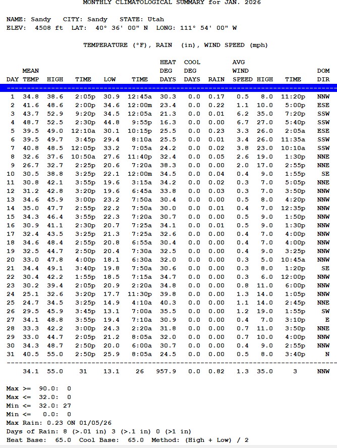
My one-line summary: Temperatures were crazy warm, and precipitation was well below normal.
Temperatures were elevated. The mean temperature was 34.1 F (1.2 C) versus a twenty-nine-year average of 29.5 F (-1.4 C) or 4.1 F warmer. Precipitation was well below average. The total for 2026 was 0.82" (2.1 cm) versus a 29-year average of 2.50" (6.35 cm), well below normal.
So what caused the warm and dry? High pressure dominated the west, while east of the Rockies, it was cold and snowy, even down to Florida.
Typically, the polar jet stream changes position every two weeks. This year, the ridge (high pressure) was over the West, while the trough (low pressure) was over the East. As anyone west of the Mississippi and for the last few weeks west of the Rocky Mountains, they'll all say, "It's been a tough, cold winter."
Can we escape this drought with enough precipitation to get through the coming summer? That answer is we'll need rain in March, April, and May to meet or exceed their averages. Here in Sandy, those averages are: March 2.08" (5.3 cm), April 2.38" (6.0 cm), and May 1.82" (4.6 cm). Those amounts total 6.28" (16.0 cm)