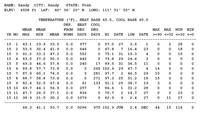
Calendar Year 2015 Climatological Summary
Temperature
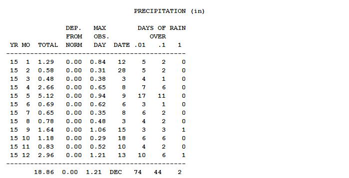
Precipitation
Wind

Temperatures ranged from 102.9F on June 29 to 2.4F on December 27. Total precipitation was 18.86" with 5.12" in May 2015 being the wettest month. The maximum wind speed was 42 mph on November 3.
December 2015 Climatological Summary

Finally we had a "normal winter month" with snow and seasonably cold temperatures. The set up of "El Nino" off South America's pacific coast indeed changed the weather pattern for this winter season. Luckily this winter should be more normal than last and hopefully will provide sufficient snow in the mountains to replenish our reservoirs. Southern Utah will probably do get more snow than northern Utah.
Two major winter storms hit December 10 and 25th (Christmas Day). The storm on the 10th produced 16" of snow, while the Christmas day storm produced another 6.5 inches of snow. Combined, these two storms produced more snow that all that came during the 2014-2015 winter season. They were welcomed, as they really added to snow in the Wasatch mountains. The Christmas Day storm included lake effect snows over parts of the Salt Lake Valley including Sandy, while the southwest part of the valley largely missed out.
November 2015 Climatological Summary
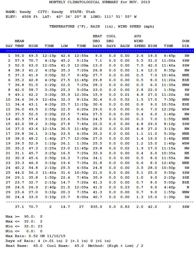
Frost did not come this year until November 7th. That was quickly followed by the first snow of the season on November 10. While the frost was late, the snow was pretty much on schedule. Things remained on the dry side as there was no more precipitation until the 28th of the month. The month was slightly drier than average and somewhat warmer than average.
November 10, 2015 - Just 3 days after the first frost we get the first snowfall in the Salt Lake valley. About 2 inches of snow fell providing a half inch of water.

November 7, 2015 - First FROST of the season this morning. Actually the temperature went below 32 at 6:45pm on the 6th as cold air moved in. The temperature bottomed at 7:45 22.0 degrees. Normally the first frost in the Salt Lake valley happens around October 13th. So this year it happened nearly a month later. It is very unusual that at the time of the first frost that the temperature plummets to 10 degrees below freezing. Leaves started falling from the trees by the bushels.
October 2015 Climatological Summary
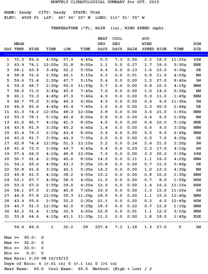
October 2015 continue the trend of somewhat below normal precipitation. The total for the month was just of an inch. There were three rainy periods, October 2-3, 17-20 and 29-30. What was unusual was that the temperature never fell below freezing! It came close on the 28th at 32.2 degrees. Temperature really cooled down on the 27th.
September 2015 Climatological Summary
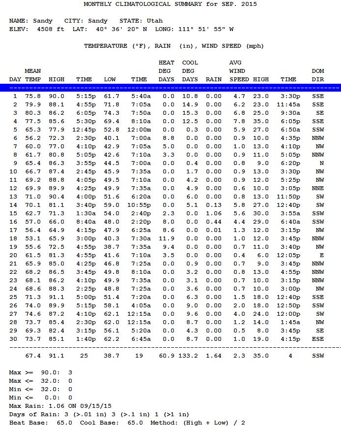
September 2015 was rather normal temperature wise and a bit below normal with respect to precipitation. All of the rain happened in the middle of the month; September 14-17; with over an inch on September 15.
August 2015 Climatological Summary
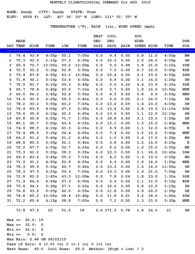
August 2015 - HOT and DRY Generally August is hot and dry; however, this year the hot extended all the way to the end of the month, which is unusual. 15 days with temperatures above 90 degrees is a bit higher than normal. The last such day was August 28th. The total rainfall was 0.78 inches more than half of which came on August 3rd. The total for 2015 is just 12.25 inches which means that the rest of the year will need to be incredibly wet to bring us up to the average of 19.14 inches for the calendar year.
July 2015 Climatological Summary
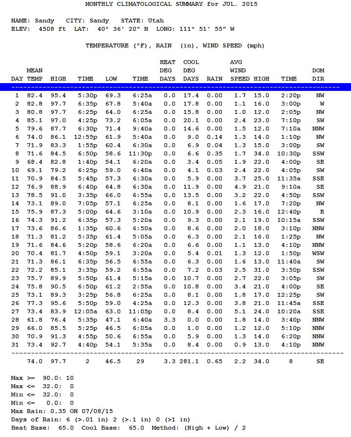
July - Cooler and wetter than normal (except for Sandy) - A very hot end of June and very early July quickly turned to a cooler early in the month. July 2nd and 3rd were the hottest days of the whole month at 97.7 degrees. Usually the hottest part of the year is July 15 - August 5. This year the hottest period will be June 24 - July 4. Unless something crazy happens those days will be the hottest period of the Summer of 2015. There was a wet period between July 6 and 10. Other areas near Sandy received a lot more rain than the 0.61" that fell here. The total for the month of 0.65" was about normal. The highest wind speed of 35 mph occurred not surprisingly on the wettest day of the month - July 8.
June 2015 Climatological Summary
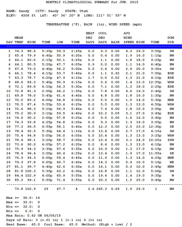
June - Just About Normal - June 2015 was pretty much a normal June. Like usual, early June was wet at time. Sandy missed out on most of that, but heavy rains did hit northern Utah on June 6. Like normal, as soon as about the 10th of the month arrives, the weather turns DRY. This year there was no precipitation after June 7th. AGAIN, the driest day of the year in the Salt Lake area is June 28. True to form there was no rain that day. The only part of June that was a bit abnormal was the very hot temperatures at the end of the month. Both June 28 and 29 were over 100 degrees, hotter than normal, but not unheard of for late June.
May 2015 Climatological Summary

Finally the Spring Rains CAME. May 2015 was a wet month; but guess what May 2011 was even wetter and that was not so long ago. Any time we get of 5 inches of rain in a month, that a big number because it represents 25% of the expected precipitation for the entire ayer. This May our Sandy Utah Weather station recorded 5.12 inches of rain. May has 31 days and only 10 of them were rain free.
The MAY rains were not enough to break our current drought, but it improved our situation greatly.
Also unusual was the fact that there was NO FROST in May 2015. The coldest temperature was 36.5 degrees on May 11.
Looking ahead - June is usually DRY except for the first week of the month, with the last week of June the statistically driest week of the year. It almost never RAINS on June 28; like less than 1% of the time.
April 2015 Climatological Summary
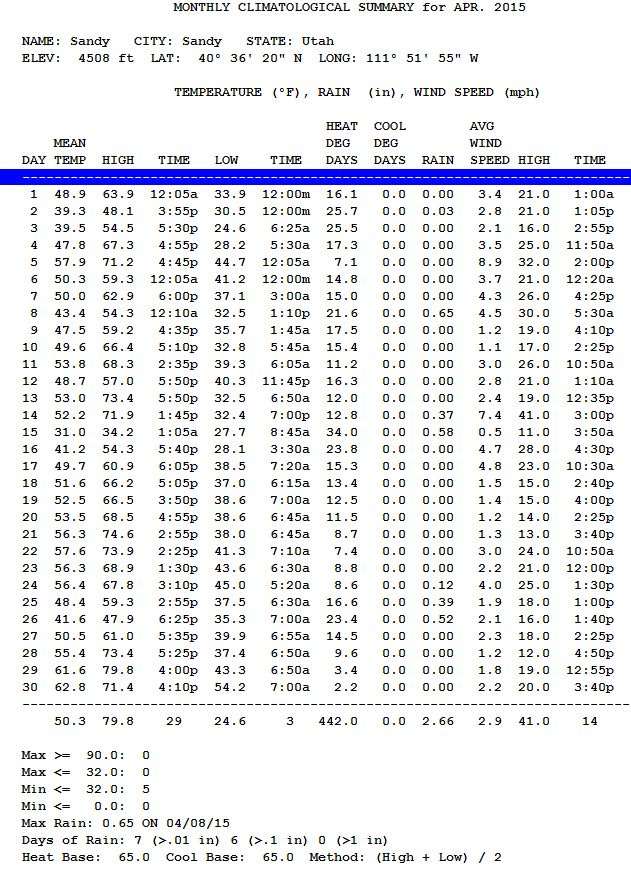
The cold front hit Tuesday afternoon at about 2:30pm. The high winds that had reached 39mph from the south shifted to the northwest. We still had to wait two hours before the rain started; quickly changing to snow. On Wednesday the snow total was enhanced by the Great Salt Lake, a low pressure to our northeast over western Wyoming, brought cold air across the lake, enhancing the amount of snow that fell.
March 2015 Climatological Summary

February 2015 Climatological Summary
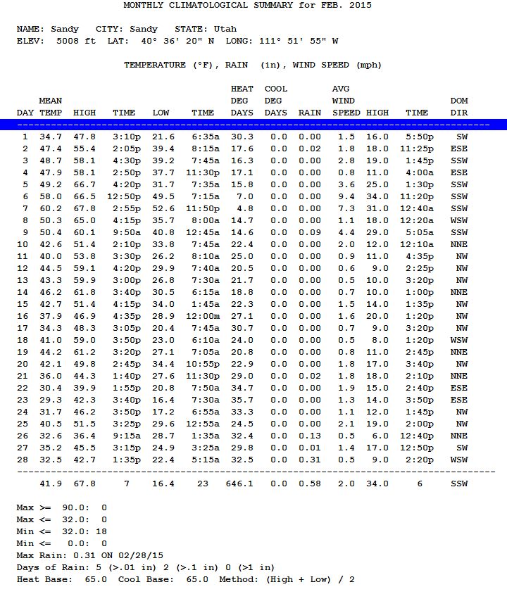
There was very little precipitation except for the last few days of the month (when the wave shifted to the west briefly). For a time it looked like March was coming in as a "Lion" and that the first part of the month would stay wet; but then the wave shifted back East and that was the end of what could have been a wet period for Utah.
January 2015 Climatological Summary
